What Happens on the Amazing 3-day Fraser Island Tour?

Disclaimer: This blog contains affiliate links meaning I earn a small percentage of every purchase at no cost to you.

The beautiful Fraser Island is listed as a World Heritage Island located off the southern region of Queensland. The largest sandbar island that stretches a total of 123 km in length and 22 km in width. A very popular tourist destination for families and young backpackers. So, after driving up from Sydney on our Australian Road Trip. We went on a Fraser Island Tour. A three-day trip across to Fraser Island, where we didn’t have to drive. What a welcome relief.

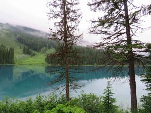
Fraser Island Tour Day 1: Lake Birrabeen – Lake Wabby

So, this day was eventful. Our first day on Fraser Island. We chose the tour with the self-driving 4×4 jeeps. There was a total of 4 jeeps with about 6/8 people in each. With the groups sorted the night before, we just had to load the jeeps and hit the road. It felt so good not having to drive. A short ferry ride over, we were ready for a new adventure.

First Stop of the Trip Lake Birrabeen…

Here, we had our lunch by the gorgeous lake. This lake has white sand lining the shores, cool crystal-clear water. However, this differs slightly as it sits above sea level. It is a collection of rainwater with no streams or rivers. A perched lake. What is amazing, is that all organic matter is filtered out. So, you won’t find any living things in the water. How crazy!!

When we were ready to move on… there was a problem. One of the jeeps wouldn’t start. So, with the guide, we raced back to the ferry to collect another jeep. The speed was faster than the drive out to Lake Birrabeen but so much more fun. As we hit the bumpy sandy road. The 4×4 driving that I am used to.

An Afternoon at Lake Wabby…

Lake Wabby and the sand dunes on the Fraser Island Tour
The Rolling Sand Dunes into Lake Wabby

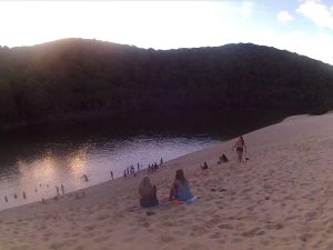
Well… after the detour put us kind of, of schedule. We still made our way to Lake Wabby. Again, a perched dune lake just like the 40 other lakes on Fraser Island. However, this is the deepest at 11.4 metres and the least acidic. Plenty of life in this lake so don’t be surprised if something swims against you. This lake is surrounded by giant sand dunes which one day will fill the emerald-colored lake. This place was fun as you can roll down the bank and go swimming… well if you are me, get pushed into the water!! The group were all getting along and were all laid back.

Due to all the commotion with the jeep. We found ourselves finishing the long walk back in the dark with minimal light sources between us. Normally, the group would be safe at camp by now. However, despite the non-optimal conditions, we made it back only with a few stumped toes.

Luckily, the camp was already set up. So, dinner, drinks, and fun before bed rounded off a great day. What a fun start to the Fraser Island Tour!

Fraser Island Tour Day 2: Shipwreck – Champagne Pools – Indian Head – Eli Creek

The shipwreck on 75- Mile Beach in Australia on the Fraser Island Tour
The Shipwreck

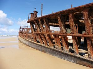
The second day was action-packed. Starting our day driving to the shipwreck along the famous 75-mile beach. A pure sand beach that runs for a whopping 75 miles. An old ship who couldn’t beat the unbelievable strong currents in the sea at Fraser Island lays here. This shipwreck gets buried deeper in the sand with each passing year. One day it will be completely buried if it is not already. The sea here is way too dangerous to swim in because of the waves and currents. Also, due to the likelihood of sharks swimming around. Great White Sharks to be precise.

A Relax in the Champagne Pools…

The Champagne Pool on Fraser Island Tour on the East Coast of Australia
The Relaxing Champagne Pools

After, a long walk in the sun across an easy boardwalk you reach these awesome pools of water. They are heated nicely from the sun. As well as, a rock wall that protects you from the sea. Plus, these cool organisms live on the rocks and you press them and out squirts water… a mini water gun!

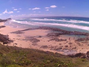
A viewpoint at Indian Head…

Indian Head is a viewpoint which looks over the sea. It was a small climb up but nothing dangerous. One part is a sacred site for the aboriginals so don’t be that person and climb all over it! However, there were some people who clearly didn’t listen. The view across the bay was insane. When I think of Australia I think about beaches like this. The golden sand between your toes. The waves in the sea. Imagining you can surf them all. I can’t surf, so my imagination is all I have here. The water is so clear that we were able to see a Minke Whale swim on through. My first ever Whale. Exciting.

Floating Down the Eli Creek…

My friends and I floating down Eli Creek's lazy river on the Fraser Island.
Floating Down Eli Creek Lazy River

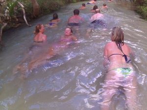
Yep. This island even has a lazy river. Simply, walk to the start, plop yourself in the water and float on down. If you are like me, you will do it again and again. I love being in the water. It wasn’t that quick and quite shallow but still relaxing. The sun was still out. My tan was coming along nicely. Bliss.

Our Final Night…

So, we cooked dinner as our mini-group. Basically, each 4×4 was in charge of their own food and drink. You purchase it all then bring it over with you. Make sure you bring enough to drink! We ate another good dinner and the drinks were following nicely… too nicely some might say.

We are all having fun and the next minute one of the girls ran out screamed… it’s only 10 pm. Yes everyone was way past drunk including me by 10 pm. You see when on the island you really don’t have any concept of time… we weren’t glued to our phones. This was nice. It felt like a total disconnect from the world. You could almost pretend you were on a deserted island but with others, food and transport.

The night of drinking continued. But, as it got chilly, we went into the back of the 4×4 and that’s when the dingos came. Dingos can be described as wild dogs but here on Fraser Island, they aren’t scared of humans. The group who were on the beach came back and scared them all off. Phew.

Fraser Island Tour Day 3: Lake Mackenzie – Kingfisher Bay

The crystal clear waters and white sandy shoreline of Lake Mackenzie on Fraser
The Beautiful Waters of Lake Mackenize

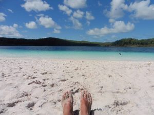
The final day and the final lake. Lake Mackenzie. Wow! This is breath-taking. The crystal-clear freshwater was amazing. This is the most visited lake on the island. When you see it with your own eyes it’s easy to why. The picture-perfect white sand squeaking beneath your feet. The water was a nice 22 degrees and refreshing. A perfect spot to relax for the last morning on Fraser Island.

Kingfisher Bay…

At long last, we arrived at Kingfisher Bay. The ferry port to get back across the water. Hungover from the night before and about to get on the ferry… I wasn’t feeling great. Plus, I get seasick. The ferry ride back over wasn’t a bundle of laughs for me. I hung out at the back praying not to be sick.

Finally, back on land. What a fun-filled three days on the Fraser Island Tour, non-stop laughter. However, after no shower, I was happy to freshen up and sleep away the hangover. I definitely, recommend booking the tour for this one. You can just kick back and drink all day. Unless you want to drive obviously.

Australia has plenty of group tours available all over the country. I even did the Ayers rock tour.

Excellent Hike to Machu Picchu – A Stunning World Wonder

Disclaimer: This blog contains affiliate links meaning I earn a small percentage of every purchase at no cost to you.

We had always planned to hike to Machu Picchu. This was what I wanted to do for my birthday. We didn’t book the Inca Trail in advance because we didn’t know exactly when we were going. Plus, it was too late to book as it fills up months in advance.

Finding the Salkantay hike was simple and now you can book in advance with an even better company. Some say it’s better than the Inca Trail as there are fewer people and it is much much cheaper. We were lucky as we booked it the day before in-person in Cusco. Overall, we paid US$200, you are paying for basic food and accommodation though. We didn’t mind this.

Day 1 – Machu Picchu: Mollepata and Challacancha

On the first day, we took a mini-bus to the starting point at Mollepata. We were roughly 2900 metres above sea level. This place provided us breakfast before setting off on the four-day hike. I’ll be honest here; I’ve never done more than a day of hiking in a row. I didn’t know what I was letting myself in for. Not only would we cover a lot of kilometres we were going to be at altitude. Something that is completely new to me too. We arrived in the main town of Cusco the day before we started hiking… let’s say this was our first rookie mistake.

Anyway, we set following our guide uphill for the next 40 minutes. Then it was flat for the next 13 km to Challacancha (3600m). Not too bad, this was the camp for the night. However, I got bitten by a mosquito on the way to camp. This is pretty standard and I’m sure there would be more to come.

A Struggle to Lake Humantay

Lake Humantay on Salkantay Hike with clear water and snowy mountains
The Struggle to This Lake Was Real

After a basic lunch, it was time to venture to Lake Humantay. A stop not on the Inca Trail and only on the Salkantay Trek. It was a further 400 metres up from camp. I have never struggled so much in my life… well, it certainly felt like I was going to die. I know extreme but I over-exaggerate.

However, at the time it felt like this but I am not one to give up I kept on pushing through. Cheered on by one of the group members, I slowly made it. It was worth all the torture I had just suffered. The view was breathtaking, a crystal-clear lake with snow-capped mountains as the backdrop. Beautiful. This view was a first for me seeing this and it is well and truly edged into my memory for life. It’s moments like this that make the hard work worth it.

Day 2: A Hike up Salkantay Mountain

So, this day wasn’t our finest hour either. We hadn’t acclimatised to the high altitude before beginning this hike and now we started paying the price. The lack of oxygen was a struggle… we couldn’t hike this morning. Luckily there was an alternative… a horse. Something I have never been on and something my friend was allergic to. Yet, this was the option we had because of our first rookie mistake we were now making another.

You are probably wondering why this was our second rookie mistake… maybe it was the fact we were riding along the side of the mountain with a sheer drop on the edge or with horses that weren’t completely steady on their feet. The prospect of dying was high in our thoughts (again) however this time I feel it was justified.

Our mistake was riding the horses as these horses weren’t treated all that well. Unfortunately, I have seen worse. These were a healthy weight and made for this purpose. On the other hand, the luggage horses were driven up the mountain. This was not nice to witness as stones were thrown in their direction. I guess, people hike this section, therefore, this doesn’t get seen. It doesn’t make this right.

Heart Pumping Hard…

The top of Salkantay Mountain at 4,629 metres above sea level
The Snowy Top of Salkantay Mountain

Once on the top of the mountain, I could relax, once again. The worst ride of my life was over. I let all the tension from that ride go. We were 4630 metres above sea level on top of the Salkantay Mountain. It was so magical as a few snowflakes fell. I love taking a moment and taking in my surroundings as nature is magnificent. After, back down we went moving slowly away from the cold.

After lunch was another 15 km hike to the second and final camping night. This was physically tough as it felt like I was dragging my feet along. We didn’t even do the uphill part but yet this was still a struggle. It was up to my mental toughness to drag me through to camp. We did it. A long time after the others but still within the 3-hour guide time.

Day 3: A Day Hiking to Aguas Calientes

This was the lowest altitude we had been in so breathing was finally back to normal. We were only 1450 metres up. This morning’s hike was 16 km along what our guide told us was an Inca Flat. This meant steep up and downs followed by Peru Flat which was manageable ups and downs. This was through the jungle and the weather threw showers, sun, warmth, and cold at us; so undressing and dressing back up kept us entertained as we burnt through the kilometres.

We started walking in the wrong direction because our guide was so far in front, that he lost us. We went up the river bank instead of in line with the river. A guide over the river told us to turn around and take the other option. Phew… I didn’t fancy being lost somewhere in a Peruvian jungle. Although that would have been interesting.

The Peru Rail train to Machu Picchu going along the tracks
The Train That Nearly Hit Me

The last part of the hike was from Hidroelectrica to the town where Machu Picchu is (Aguas Calientes). This was a flat 2-3 hours walk. We took it at an unhurried pace. I would say to enjoy the last bit of the hike but it was due to sore, achy muscles. There wasn’t much to look at as it was along the train tracks. As exciting as this walk got was nearly getting hit by the train. We left as much clearance as possible. We thought we were far enough back from the tracks but the train is much wider than the tracks. Luckily, we made it to the Aguas Calientes in one piece… just.

Day 4: Visiting the Ruins of Machu Picchu                                              

One view of Machu Picchu with low cloud
The Weather Failing Us At Machu Picchu

Waking up knowing that a day of hiking wasn’t on the agenda was gold. We set off earlier than the group to catch the bus (the cheaters’ way). But it had to be done because every muscle was sore. Once, in the grounds of Machu Picchu, the excitement was high as we explored yet another masterpiece. However, mother nature showed up too.

Yes, that’s right like most trips to Machu Picchu the early morning rains and clouds ruin the views. They lasted into the afternoon for us. We didn’t opt for the train back so another walk along the train line was in order. Finally, a waiting bus took us back to Cusco. I would recommend paying the extra for the train as you get longer at Machu Picchu.

The view of Machu Picchu from the top of the mountain
The View from The Top of Machu Picchu

Summary of the 4 Day Salkantay Hike to Machu Picchu

I have not sugar-coated how tough we found it from day 1 to day 4. Would I do it again? The answer is yes. Would I make changes? The answer is yes. We were very underprepared for the challenge that greeted us. Yet we still managed it. As tough as it was, I did enjoy pushing myself to extremes. And the sense of accomplishment when it was all over was unreal. I was so proud of myself. This means if we managed it, you can too!! It was so rewarding. The views, the different climates, changes in landscapes and Machu Picchu makes it well worthwhile.

P.S remember that mosquito bite on day 1… our third rookie mistake not taking anything to treat it with. It ended up bursting a couple of times meaning an infection got in. I was lucky that some over-the-counter antibiotics got rid of it. It could have been much worse.

Please go more prepared than us!!

Remember to check out my other South American adventures here!!

A Day Out on the Amazing Salt Spring Island

Disclaimer: This blog contains affiliate links meaning I earn a small percentage of every purchase at no cost to you.

Salt Spring Island is the largest island in the Southern Gulf Islands. You can access to Salt Spring Island by a ferry either from Vancouver Island or the Mainland. In my eyes, it is worth a day visit. The ferry leaves from Crofton on Vancouver Island and arrives at Vesuvius, Salt Spring Island. The journey only takes 25 minutes and a full day of exploring awaits. I would recommend having a car for this trip. There is a small bus route around the island but not very practical.

Salt Spring Island is famous for its Art Culture, organic farming, rugged coastlines, and natural beauty. There is plenty to explore on the island. We knew what we wanted to see and set off early. Also, starting early helps you to avoid hiking in the mid-day sun especially in the height of summertime. This is a must as it gets very hot.

A Morning Hike up the Magical Mount Erskine

The first point of call from the ferry was Mount Erskine. The trailhead was confusing to find. It does indeed have multiple entrances. The first entrance we arrived at looked like it was someone’s house (or so we thought). So, we did a bit more googling and found another starting point. We headed over to that one. This looked much better as there was a trailhead this time. I am not completely sure which trail we did, to be honest. We parked up at a turn-around area; I couldn’t tell you what road it was on.

Before setting off up Mount Erskine in search of what this trail offers, breakfast was on the menu. One of the best things about van life is you pick what view you have when you eat. This morning’s option didn’t disappoint.

Starting the Trail…

Fairy Doors at Salt Spring Island
The Only Fairy Door We Found

The trail started by entering a small clearing. As you enter you do get the feeling this is a magical place. The point of doing this trail is to find the fairy doors that lay throughout the forest. I had decided on wearing flip-flops. Therefore, to some people my choice of footwear is silly. I know it sounds silly but I feel like I have more grip.

We only found one fairy door on the hike and we didn’t quite make it to the top. It was a very unclear trail and people had made their own paths. At one point we ended up walking along a very narrow, steep, sheer drop cliff. Don’t get me wrong the sea view was amazing and worth it but this definitely got the heart racing. This was way more intense than the morning stroll I was expecting.

The View from Mount Erskine

Overall, this trail was a good hike. If you come, I would do some research on where the fairy doors as are they are hard to find. I believe there are many fairy doors so hopefully, you have better luck than us at finding them!!

Ruckle Provincial Park on Salt Spring Island

Ruckle Provincial Park is a coastal park that starts at Beaver Point on the South-Eastern shore of Salt Spring Island. The trail was a one-way 7 km hike to King’s Cove. In comparison, this was a nice relaxing walk compared to the climb up Mount Erskine. The trail was at sea level taking you through different landscapes. As well as an abundance of wildlife to look out for such as orcas, otters, and birdlife.

Dancing at Ruckle Provincial Park

Ruckle Provincial Park’s coastal path has amazing ocean views. The trail isn’t clearly marked either (seems to be the theme of the island). At times we went off course yet it was fun exploring the surroundings. There were times where we were hugging the coastline climbing over rocks. Most of the trail edged along rocky headlands, tiny coves, and bays to explore. Look out for rock pools. For us the tide was high so we didn’t see the colourful range of crabs and other species.

When away from the coastal path you work your way through the forest. Listen out for birds and watch out for turkeys and chickens. The Quartz Fields is the other landscape to view. Yes, we did dance around like idiots in the fields. No one else was around though.

A Relaxing re-charge at Beddis Beach

After all that hiking, we earnt this well-deserved afternoon at the beach. The beach was small but delightful. The beach we visited can be found at the end of Beddis Road. We parked on the side of the road, followed a path to the sand. Also, the beach was quiet which was surprising as the sun was out.

There were only about 5 other people on the beach. People were in the nude. There were no signs that we saw to indicate if it was a nudist beach. The water was a little cold but nice to wash off all the sweat!! We kicked back and topped up our tans in the mid-day sun.

Ganges Village

The Ganges Village is the largest village on Salt Spring Island found centrally on the east side of the island. The harbour was very busy and we watched many floatplanes come and go as we ate dinner.

Best Calamari on Salt Spring Island

Well, being by the sea only means one thing for dinner; fish n chips. We shared delicious buttermilk calamari which was very tasty. The main course of fish n chips that followed didn’t disappoint either. All of the food was cooked to perfection. Finally, a good choice for our treat. When I am on a road trip eating out is rare as I try and save my budget for adventures.

Summary of Salt Spring Island

There is so much to see and do here and the island definitely has a laid back feeling to it. Also, there weren’t many other tourists either so that was great. The few people we did meet on hikes were locals with great tips and knowledge. These hikes were very different from popular hikes like the Grouse Grind. This place is worth the visit if you want to escape the crowds.

A 3-Day Tour of the Interesting Salts Flats, Bolivia

Disclaimer: This blog contains affiliate links meaning I earn a small percentage of every purchase at no cost to you.

The salt flats are another well-known attraction to visit in South America. The nearest town to the salt flats in Bolivia is Uyuni. There are two options to choose from either coming back to Uyuni or go to San Pedro de Atacama in Chile. All the tours vary in length ranging from 1-4 days. We booked our tour in the town of Uyuni last minute. This was risky as it was a busy time and we could only book with a below-par company. To get the best experience with the most reputable company you can book online here.

Day 1 Salt Flats Tour : Uyuni – Colchani – Inca Huasi – Agua Quisa

For this tour, we were a group of four as we met up with some friends. We set off in the Toyota 4×4 that fitted 6 of us, our driver barely spoke English. You can pay extra for an English-speaking guide. Again, due to booking last minute we didn’t have an option of an English-speaking guide. The first stop of the day was the train cemetery, some abandoned trains were left behind in the middle of nowhere. It was pretty cool; we climbed over them and got some pictures.

Abandoned train carriages known as the train cemetery
The Abandoned Trains

The market town of Colchani was a quick stop off. We picked up a toy dinosaur for the pictures we were going to take. This is when you start to enter the salt flats. The landscape is now all white in all directions. Sunglasses were more or less permanently on my face as the sun bounced off the salt. Sun cream was a constant of reapplying because my nose is delicate and burns with ease.

Lunchtime…

We ate lunch at an unused salt hotel. From there, we headed out to take the iconic pictures you see all over the internet. Everyone who visits gets fun and creative with their shots. The crazy ideas people come up with are all pretty cool. There is no depth perception on the salt flats therefore you can make everyday objects bigger.

A random cacti island known as fish island in the middle of the salt plains
A Random Cacti Island

By now we were in the middle of nowhere creeping our way up to 4000 metres. I didn’t realise we climbed up so many metres when on the tour. As we approached our next stop off for the day. What we saw was unexpected. I wasn’t expecting an island (Inca Huasi/Fish Island) in the middle of the salt flats. However, here one was. A unique island made up of cacti randomly in the middle of the salt flats. The sun was setting on our way to the Salt Hotel at Agua Quisa. We pulled over to admire the sunset. Once at the hotel dinner was eventfully served. It was worth the wait.

Day 2 Salt Flats Tour: Chiguana – Lagunas – Siloil – Laguna Colorada – Sol De Manana

Me jumping for joy on the Salt Flats
Jumping for Joy

As we made our way to the 4×4 in the morning, still half asleep. It was another early morning to fit everything in. Our driver/tour guide was putting air into not one but two tyres. This was not a good sign or a great start to the day. Here, I was hoping they were slow punctures.

After a short drive, we left the salt flats behind to enter the desert. Compared to other groups… we arrived very slowly. I wonder why. It is looking like we really should have booked in advance. During that drive, we stopped once on our way to pump up those tyres… I guess not such a slow puncture with all the bumpy terrain. Not to mention the times the driver stopped to check on them.

728*90

A Day of Exploring Lakes…

The lakes were full of flamingos. All of the lakes had different colour of water to them which was pretty cool. We saw two more lakes before missing the Galaxy Cave because of our slow pace. Yes, we were that far behind the other vehicles from our tour. We had to miss a stop. I was really excited to see the Galaxy cave. Oh, well!

After, a long drive we came to Siloil to see the simple stone tree structure (Arbol De Piedra). Again, we were last to arrive and one of the first to leave. So we didn’t get much time here, unfortunately. These two deflating tyres were hampering this day.

The red lake in Bolivia
The Best Lake on The Tour

Laguna Colorada known as a red lagoon was very pink in colour when the sun poked through. There was one last stop before our hotel stay at the hot springs. Geysers (Sol De Manana). Here we were up at an altitude of an impressive 4800 metres. The hot steam shot up into the air from holes in the ground. As read you about them you are lucky that you can’t smell. The smell was a pure raw odour of sulphur which was extremely strong. At the hotel, we had dinner and watched the sunset. The stars were very pretty and many to see as light pollution wasn’t an issue.

Day 3: Dali Desert – Laguna Verde

Green algae on some rocks in the desert
Evidence of This Being Underwater

The last morning of our trip was a journey through the Dali Desert. There were some rocks covered in green algae. Evidence that this place used to be underwater. We stopped at a couple of locations along our way to Laguna Verde… just to make sure our tyre wasn’t flat. Lastly, after viewing Laguna Verde we caught the bus to San Pedro de Atacama. This was easy to arrange with the tour operator when booking. The bus was long but the views of the desert were beautiful and kept me entertained along with a much-needed nap!

Summary of the Salt Flat Tour

Overall, I would say we went with a mid-range company, all was good. The food was good. The accommodation was a nice room for two in the salt hotel on the first night. The second night was a shared room for maybe around 7/8 people. The only issue with the trip was of course the flat tyres. This was a pain as we missed out on going to places. However, there wasn’t a lot we could do about this.e. Overall, an experience I will never forget.

Want to check out other experiences in South America, Click Here!!!!!!!!

A Stunning Drive Through the Beautiful Yoho and Glacier

Disclaimer: This blog contains affiliate links meaning I earn a small percentage of every purchase at no cost to you.

This was the start of our road trip through the Canadian Rockies. We drove from Vancouver. Therefore for us, we entered Glacier National Park and then drive through Yoho National Park. Before hitting Banff and Jasper National Parks. Yes, they are all close together which is convenient. Yet, they do span a vast amount of BC and Alberta.

Rodger’s Pass Highway, Glacier National Park

I was ready to take on what is one of the most dangerous roads in North America. I suspected they are speaking about the Winter Season when it’s covered in snow. However, it was summer and the sun was shining. Rodger’s Pass winds its way through a gorgeous mountain range making this scenic drive simply magnificent. In every direction, you are surrounded by mountains.

Hemlock Grove, Yoho National Park

Hemlock Grove Glacier National Park
Boardwalk at Hemlock Grove

After a fair few hours of driving, we fancied stretching our legs. So, we stopped in at Hemlock Grove. This was a quiet boardwalk through old-growth forests. The path led us up close and personal with the soaring ancient Hemlock trees. The walk beneath the canopy is a cool relief from the sun burning down.

Rodger’s Pass Discovery Centre

I would describe the Discovery Centre as a mini-museum. To be able to enter all you do is show your park pass. It is small and informative but I find learning enjoyable. Although there was not much on display I still enjoyed it. The museum detailed the history of Rodger’s Pass and what wildlife lives in Yoho National Park.

Northern Lights Wildlife Wolf Centre, Golden, BC

I kept this stop as a surprise for my friend. Google maps was used as this place was really in the middle of nowhere. She definitely was surprised as we pulled into the car park. We went to a small unique sanctuary for wolves. We even timed it to perfection arriving at the start of the talk. The host was very knowledgeable and the talk was informative. We learnt a lot and saw wolves, therefore, it was worth a detour.  

Kicking Horse River

The Kicking Horse River is very powerful and loud. However, we found a picturesque free spot for the night. It was beautiful. Nice and relaxing, a real winner in free camping spots. We left early in the morning to continue the adventure. Leaving the nature spot just as we found it.

Natural Bridge Over The Kicking Horse River, Yoho National Park

Natural Bridge Yoho National Park
Impressive Formation of a Natural Bridge

As always, we enjoy stopping off at most of the viewpoints along the highway. This breaks up the drive and we get to see the awesome natural wonders of Yoho National Park. In addition, this stop was no different. The natural bridge is a naturally shaped rock formation and extends the entire width of the Kicking Horse River. Sculpted by the erosive forces of the rushing water.

Emerald Lake, Yoho National Park

Emerald Lake
The Beauty of Emerald Lake

This was one lake I was really excited to see; well if I’m honest I was enthusiastic about everything. So, when I saw the deep vibrant turquoise colour as the sun peaked through the morning clouds; I was beyond ecstatic. This is a glacier-fed lake like most of them in the park. The colour forms because of the slit that streams into the lake. Well worth a stop!

Takakkaw Falls, Yoho National Park

Takakkaw Falls in Yoho National Park
Takakkaw Falls

This giant waterfall stood at 260m with a waterwheel starting the flow. A waterwheel is where the water shoots upwards before rushing back down. This was impressive to watch. The short walk from the car park led us across a bridge to the waterfall. The waterfall is in view for most of the walk. The weather wasn’t great which meant the crowds were quiet. The water pounds down leaving you covered in spray.

Spiral Train Tunnels, Yoho National Park

Train Spiral Viewpoint
The Train Travelling Through The Spiral Tunnel

As we drove back down from the Takakkaw Falls to Rodgers Pass we pulled into a spot for some lunch. This spot was one of the two viewing platforms for the Spinal Tunnel. We didn’t know about this until a nice guy explained it to us. We were lucky to see the train pass through the tunnel. Trains are mostly cargo in Canada and can be up to 2 miles in length. Therefore, it did take some minutes for the whole train to pass.

What a Start to The Rockies

These two National Parks kicked started the excitement for Jasper National Park and Banff National Park. The scenery was incredible and the drive was pleasant. The breathtaking views made this trip worthwhile.